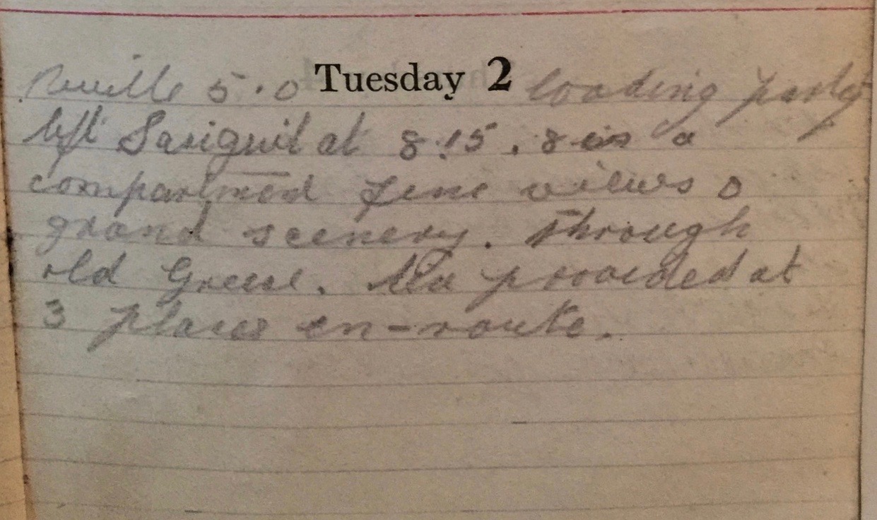
Tuesday July 2nd, 1918
Reveille 5am. Loading party. Left Sarigueul at 8:15 in a compartment. Fine views and grand scenery through old Greece. Tea provided at three places en-route.
Places en route to the Greek Coast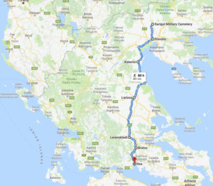

Today and tomorrow the Battalion will board trains from Sarigueul (Sarigöl) and journey to Itea on the Greek coast. From there they will cross to Italy and then head, by train again, to the battlefields of the Western Front.
The Battalion Diary yesterday mentioned three halts on the route to their first overnight stop at Bralo – Dudular, Ekaterina and Larissa. In the Operation Order, a fourth place is also mentioned, Lionacladi.
The Google Map shows the route the 13th took from Sarigueul to Itea. A link to the map is provided at the foot of this page.
Plotting the Route
Sarigueul is the embarkation point. It is not on any modern maps – though it was clearly marked (as Sarigöl) on those of war-timeº. The only trace of it now seems to be the Sarigol Military Cemetry near the village of Kristoni. It contains over 700 graves from WWI.
Similarly Dudular, while it still exists, is a very small place and doesn’t warrant an entry on Google Maps. The nearest noteworthy place is now Diavata.
Ekaterina is actually Katerini, close to the base of Mount Olympus. It is a large town with ancient roots and has had several names. It is possible that its most recent iteration came in the 19th century because of a small chapel to St Catherine (Aikaterini in phonetic Greek). This would also explain the BWD’s mis-spelling.
Larissa (Greek: Λάρισα [ˈlarisa]) had been an important city state of Thessaly in the ancient world.
The city minted its own coins in ~400 BC depicting the nymph, Larissa, after whom the city was named (though it is also an old word for ‘fortress’). An ally of Athens in the Peloponessian Wars, it was also home to Achilles and the place where Hippocrates died.
The city changed hands many times from the 6th century AD – settling as part of the Ottoman Empire from the mid-14th century until the Greek War of Independence in 1881. While under Turkish rule, the city was known as Yeni-şehir i-Fenari, ‘new citadel’.¹
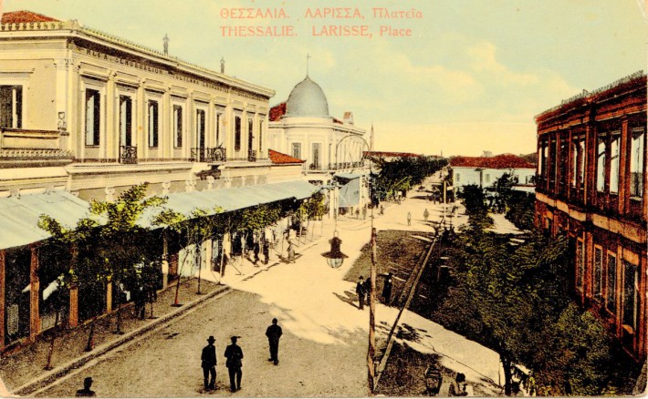
The postcard image shows what Larissa probably looked like when the 13th Battalion passed through in July 1918. It is now the capital of the Thessaly region of Greece.
Lionacladi is actually Leianokladi (Greek: Λειανοκλάδι). It is a small community. However, and pertinently, it is now a stop on the high-speed railway line between Piraeus–Platy which connects Athens to Thessaloniki. That said it doesn’t look like the 13th stopped there on this journey.
Frank obviously enjoyed these stops – if not for the scenery or the history, for the tea. In this case provided free by the YMCA.
13th (Service) Battalion War Diary – 2nd July 1918 – Bralo
HQ, A & C Coy arrived at Bralo 08:15 hrs and stayed the day in the Rest Camp. B & D Coys and Transport entrained at Sarigueul at 08:30 hrs proceeding as the 1st party.
References & Further Reading
º Kukus Map of 31-7-18, coordinates 160 / 138, from the collection of the Salonika Campaign Society
¹ Larissa on Wikipedia
² Postcard of Larissa on Wikimedia
³ Google route map from Sarigol to Itea