
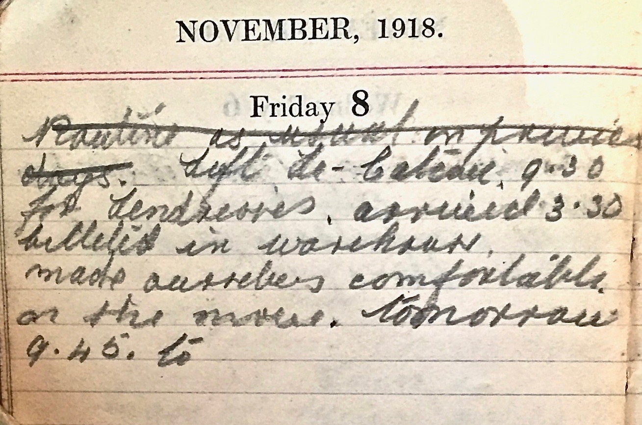
Friday November 8th, 1918
Left Le-Cateau-Cambréses at 9:30 for Landrecies, arrived 3:30. Billeted in warehouse, made ourselves comfortable on the ?? Tomorrow 9:45 to [blank]
Towards the Front
After being left behind, Frank, the Band and the B-team are moving up towards the front. Today they have marched 12kms to Landrecies.
Landrecies is in the middle of what is now, in 2018, a wildlife park, Parc Naturel Regional de l’Avesnois which hugs the French/Belgian border around Maubeuge. However according to a 1916 British Army map (Map 57a, first edition) of the area, Landrecies was then on the southern outskirts of the much smaller Foret de Mormel.¹
The rest of the Battalion, which had been in Landrecies on November 5th, is now in La Tuilerie, 20 kms to the east of Frank and co. La Tuilerie is a rural area, just to the west of their next destination, Bas Lieu. With the wounding of two soldiers today, they are clearly approaching the line of fighting.
Map, 1916
‘All together, Britain printed 34 million war maps, France over 30 million, and Germany a staggering 775 million (including the Eastern Front).’¹ ²
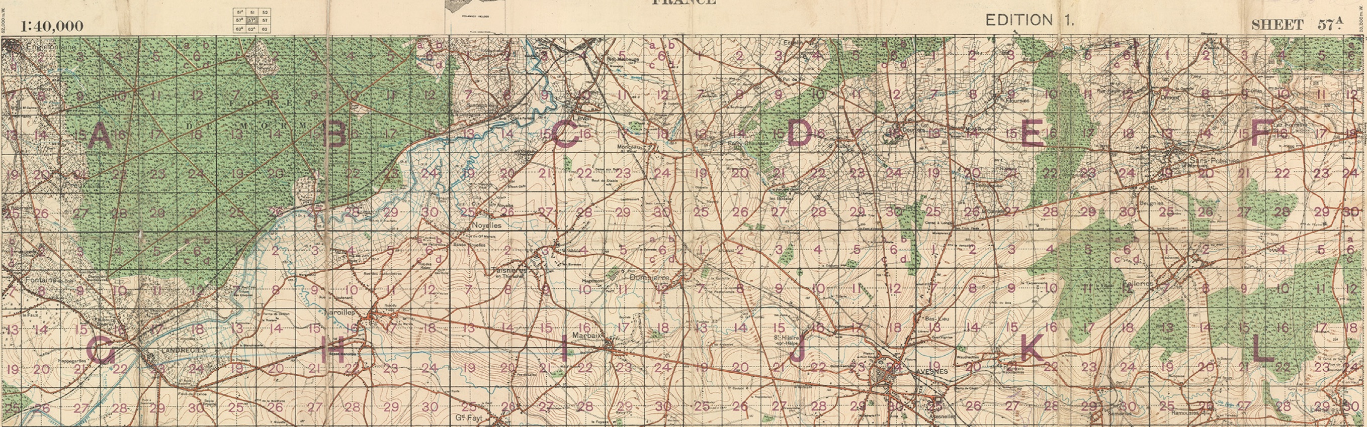
This is a portion of the Map, 57A, First Edition, 1916. A link to the full map is provided below.¹. You will see Landrecies at the bottom left. Moving to the right, Marbaix (where the Battalion billeted last night) and La Tuilerie just north-west of Avesnes in quadrant J10. Click on the map to expand.
Map, 2018
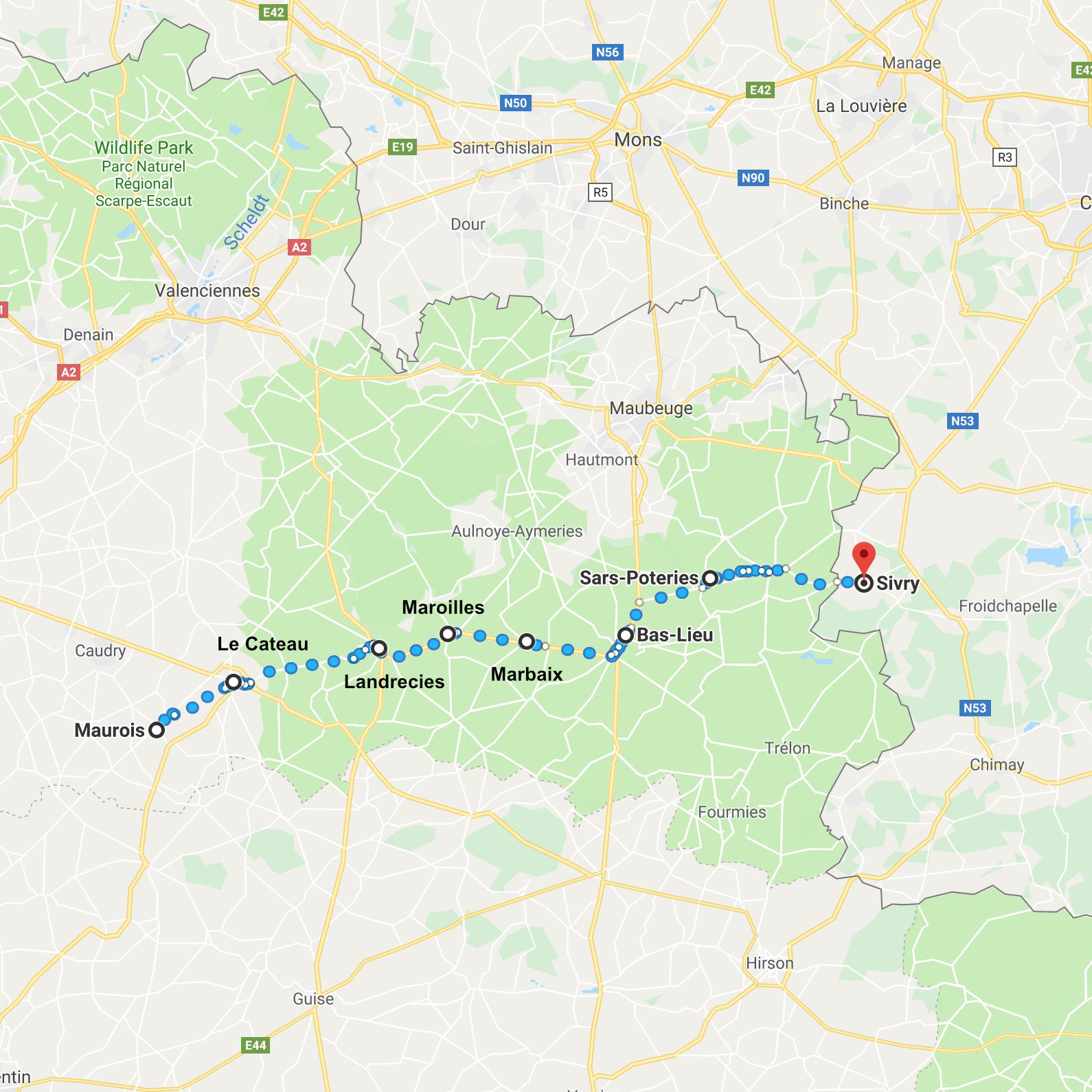
This Google map, shows the route the Battalion has taken over the past few days and will take for the remainder of the war. Their direction is relentlessly east as they drive the Germans out of France. While not marked, La Tuilerie is close to Bas-Lieu which is the Battalion’s next destination.
9th Battalion War Diary – 8th November 1918 – Marbaix
The Battalion moved in Brigade Reserve for Grand Fucheau and from there proceeded to La Tuillerie [La Tuilerie] remaining there for the night. In the afternoon 2Lt PHH Davies [Davis] and 1 OR were wounded whilst moving up as liaison with 5th Connaught Rangers.
References & Further Reading
¹ WWI Maps on Australian Government website
² ‘British, French and German Mapping and Survey on the Western Front in the First World War’ by Peter Chasseaud. From ‘Fields of Battle: Terrain in Military History’, edited by Peter Doyle and Matthew R. Bennett. Dordrecht, The Netherlands: Kluwer Academic Publishers, 2002, p. 171. (Referenced in WWI Maps above.)